Home    Garmin GPS    Handheld GPS   Rino 655t
 
     Rino® 655t
 
Rino® 655t
 

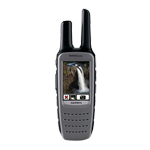
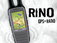
With a 5 W FRS/GMRS radio, 2.6" glove-friendly color touchscreen GPS with preloaded TOPO 100K maps, barometric altimeter, 3-axis electronic compass, NOAA weather radio and 5-megapixel camera, Rino 655t is a jack-of-all-trades

eTrex minisite

Pinpoint Your Position

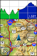
With its high-sensitivity GPS receiver and quad helix antenna, Rino 655t quickly finds your position and maintains it – even in heavy cover. Plus, a built-in barometric altimeter and 3-axis compass make it easy to get your bearings without the need to hold it level.

See Your Surroundings

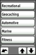
The device comes preloaded with TOPO 100K maps, which includes coverage of the full U.S. Adding more maps is easy with Garmin's wide array of detailed topographic, marine and road maps. With its microSD™ card slot, Rino 655t lets you load TOPO U.S. 24K maps and hit the trail or plug in BlueChart® g2 preloaded cards for a great day on the water. The device also supports BirdsEye Satellite Imagery (subscription required), that lets you download satellite images to your device and integrate them with your maps. In addition, Rino 655t is compatible with Custom Maps, free software that transforms paper and electronic maps into downloadable maps for your device.
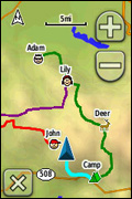
Find Your Friends

Rino 655t’s unique Position Reporting capability lets you send your exact location to other Rino users so they can see it on their map page. Plus, improved audio performance means it’s easy to communicate with any other conventional FRS/GMRS radio in the area. It can be useful in an emergency, or just a handy way to keep tabs on your hunting party, hiking partner, family or friends.

Stay in Touch

With plenty of transmit power, Rino 655t also lets you send unit-to-unit text messages to other Rino users in your area – it's ideal for loud or windy conditions, or just when you don't want to disturb the wildlife. It also lets you share your waypoints, tracks, routes and geocaches wirelessly with other compatible Garmin handheld devices.

Document Your Journey

With Rino 655t’s built-in 5-megapixel autofocus camera, you'll be able to capture the highlights of your outings. Each photo is automatically geotagged with the location of where it was taken, allowing you – or those you share your photos with – to easily navigate back to that spot in the future.

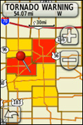
View Weather Watches and Warnings

For added safety, Rino 655t features a built-in NOAA weather radio that can help you avoid hazardous weather. The radio supports Specific Area Message Encoding, which allows you to see National Weather Service warnings and watches displayed county-by-county on the map screen.

Plan Your Next Trip

Take charge of your next adventure with BaseCamp™, software to view and organize your maps, waypoints, routes, and tracks and send them to your Garmin device. This free trip-planning software displays topgraphic map data in 2-D or 3-D on your computer screen, including contour lines and elevation profiles. It also can transfer an unlimited amount of satellite images when paired with a BirdsEye Satellite Imagery subscription as well as geotag photos, or associate them with specific waypoints.

  Weather the Storm

  Weather any storm with Rino's built-in NOAA weather radio that helps you avoid hazardous   weather. The radio displays county lines and storm watches/warnings on the map screen so   you'll always be in the know...and safe.

  Advanced Contact Tracking

  What's in a name? A lot when it comes to Rino. Now, you can track 2,000 points of   information per contact. Plus, the track manager makes it easy for you to maintain   and review   who you've been tracking.

  Improved Notes

  Gone are the days of missing a note. Rino time stamps and records the notes you   receive   from contacts for later review, or forwarding.

  Dashboards

  Bring more functionality to your device with more dashboards in more places. View   your   elevation plot, coordinates, compass arrow and more on any page, at any time.

  Multiple Personalities with Multiple Profiles

  Customize Rino to be as well-rounded as you. You can set up different profiles so you   can   quickly switch personalities based on what you're doing - hiking, driving or more.   With Rino,   you'll never miss a beat.

  View Multiple Contacts

  Stay with your group, even when they are far away. Rino lets you view multiple   contacts on 1   screen, so even if you're far away, you can see where they are in   relation to you. Plus, you   can easily route to your friends or regroup if you need to.

Rugged GPS + Radio

  • Uses HotFix® and a high sensitivity receiver and quad helix antenna to acquire satellites

  • Offers an improved base map with Digital Elevation Model

  • Offers improved mapping support with access to TOPO U.S. 24K, BirdsEye Satellite Imagery, Garmin Custom Maps and more (sold separately)

  • Uses a universally accepted GPX file format to store your data and allow compatbility with your computer

  • Offers a 2.6" glove-friendly color touchscreen

  • Allows you to send unit-to-unit text messages to other Rino users via radio signals


Physical Performance
Unit dimensions, WxHxD: 2.4" x 7.5" x 1.8" (6.0 x 19.0 x 4.5 cm)
Display size, WxH: 1.43" x 2.15" (3.6 x 5.5 cm); 2.6" diag (6.6 cm)
Display resolution, WxH: 160 x 240 pixels
Display type: transflective, 65-K color TFT
Weight: 11.3 oz (320 g) with battery pack
Battery: removable, rechargeable lithium-ion battery pack
Battery life: 14 hours (up to 18 hours with optional AA battery pack)
Waterproof: yes (IPX7)
Floats: no
High-sensitivity receiver: yes
Interface: high-speed USB and NMEA 0183 compatible
 
Maps & Memory:
Basemap: yes
Preloaded maps: yes (topographic)
Ability to add maps: yes
Built-in memory: 4.5 GB
Accepts data cards: microSD™ card (not included)
Waypoints/favorites/locations: 2000
Routes: 200
Track log: 10,000 points, 100 saved tracks
 
Features & Benefits:
Automatic routing (turn by turn routing on roads): yes
Electronic compass: yes (tilt-compensated, 3-axis)
Barometric altimeter: yes
Camera: yes (5 megapixel with autofocus; 4x digital zoom; automatic geo-tagging)
Picture viewer: yes
Unit-to-unit transfer and ANT+™ compatible: yes
Hunt/fish calendar: yes
Sun and moon information: yes
Area calculation: yes
 
Other:
Frequency band: FRS and GMRS
Channels: 22
Squelch codes: 38 (CTCSS); 83 (DCS)
Transmit power: 0 - 5 watts
Range: Up to 2 miles over FRS; up to 20 miles over GMRS
VOX (voice activation): yes
Location reporting (send and receive GPS positions): yes
Vibration alert: yes
NOAA weather radio: yes

What's in the Box:

  • Rino 655t

  • Lithium-ion battery pack

  • USB cable

  • AC charger

  • Carabiner clip

  • Manuals


View all | Collapse all

 Mounts


Auto Friction Mount
010-11602-00


Marine/Cart Mount
010-11031-00


Bike/Cart Mount
010-11023-00


 Cables


Vehicle Power Cable
010-11598-00


Serial Data/Power Cable
010-11131-00


USB Cable
010-10723-01


 Batteries


Alkaline Battery Pack
010-11600-00


Li-ion Battery Pack (Replacement)
010-11599-00


 Lanyards, Straps, Holsters and Clips


Belt Clip
010-11022-10


Belt Clip
010-11734-20
Temporarily out of stock


 Fitness Sensors


Speed/Cadence Bike Sensor
010-10644-00


Premium Heart Rate Monitor (Soft Strap)
010-10997-02


Speed/Cadence Bike Sensor (Replacement)
010-10729-00


 Other


chirp™
010-11092-20


 On the Trail Maps


010-D1281-00
Temporarily out of stock


GARMIN GPS 
   Handheld GPS 
   Automotive GPS 
   Marine GPS 
FENIX TORCH 
   Rechargeable Torch
   E-Series Torch
   TK-Series Torch
   PD-Series Torch
   LD-Series Torch
GOAL ZERO 
   Solar Kits 
   Solar Panels 
   Power Packs 
AAXA
   P2jr Pico Projector
   P300 Pico Projector
BRINNO
   Time Lapse Camera
   Motion Activated Camera
   Peephole Viewer
SPYPOINT
Camera Traps
Laser Range Finders
   Dummy Trail Cameras
PRECASTER
Distance Meter-CA740
Distance Meter-CA770
GPS TRACKER
   Personal Trackers
   Vehicle Trackers
 
© Copyright 2013, Satcom Zone, All Rights Reserved Home  |  Sitemap  |  Careers  |  Contact Us